Spatial Intelligence, defined (in one sentence)
Spatial Intelligence in real estate is the practice—and product discipline—of converting zoning rules, overlays, and compliance signals into a visual, decision-graded model of what a property can become, what it can't, and what will slow it down.
That last clause matters: decision-graded. Most tools show data. Spatial Intelligence prioritizes reality.
The common failure mode is not lack of information. It's lack of decision-grade understanding.
- A building looks like it can be expanded, but zoning (or an overlay) says otherwise.
- A property appears straightforward, but historic constraints add months of approvals.
- The listing suggests "value-add," but buildable opportunity is limited by envelope rules.
- The plan assumes speed, but violations become timeline killers.
Why zoning text alone is insufficient
Zoning is foundational, but zoning text is not decision-friendly. Most people experience zoning as either a district label ("R6B," "M1-4/R7-2") or dense regulatory language. Both are necessary. Neither is sufficient.
1. Zoning is spatial, workflows are textual
Zoning governs 3D outcomes. Consuming it as text requires constant mental translation—where expensive mistakes happen.
2. "Buildable" is a gap, not a number
Real buildable opportunity depends on massing, geometry, height limits, yards, overlays, and approvals posture.
3. Overlays are where reality lives
In NYC, the base district is only the beginning. Overlays and regulatory layers redefine what's realistic.
4. Decisions need "blocking vs warning"
Users don't want more data. They want: Can I do this? How hard is it? What's the smartest next step?
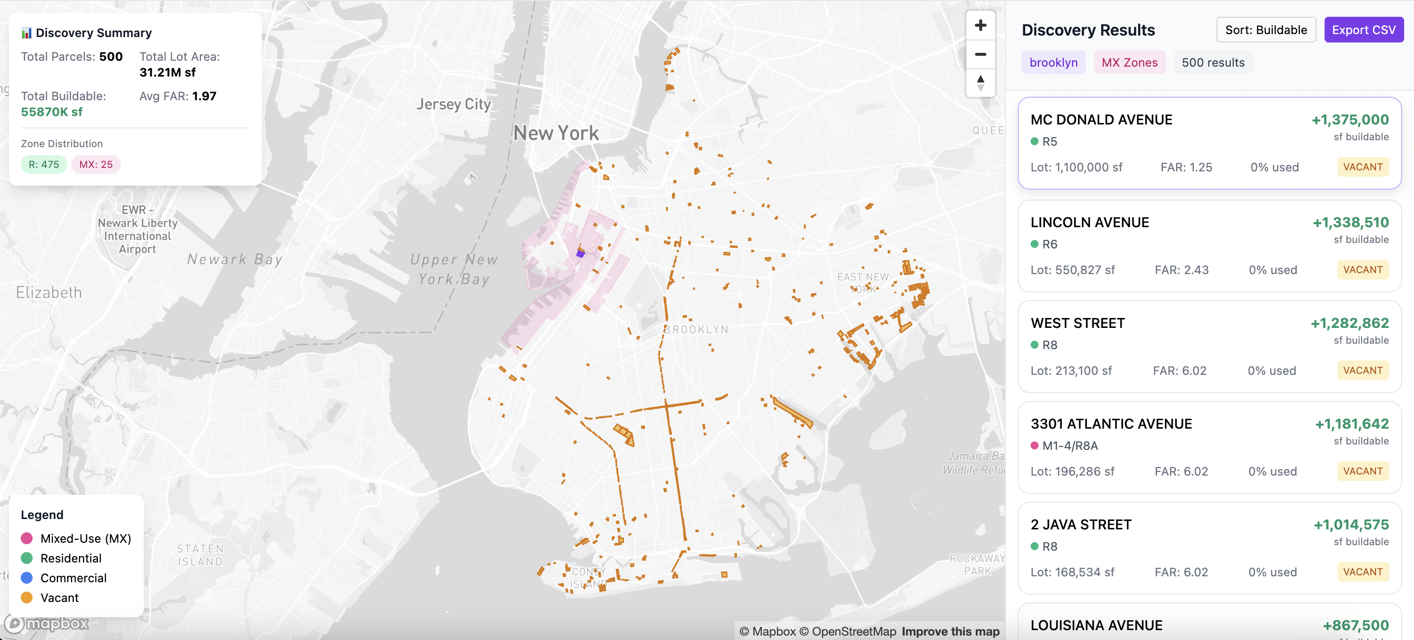
The three pillars of Spatial Intelligence
Spatial Intelligence works because it fuses three layers into one decision interface. Each layer matters alone. The power comes from seeing them together.
Zoning Capacity (what the rules allow)
At the heart of Spatial Intelligence is zoning capacity: what a property is allowed to become under governing rules.
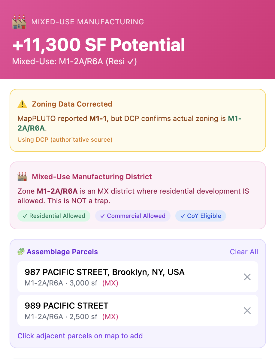
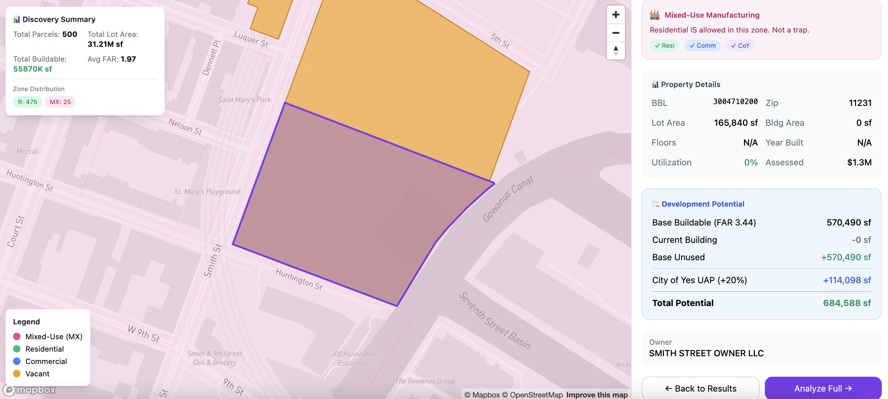
Air Rights (the opportunity gap)
Air rights are the economic value of unused development capacity—constrained by geometry, adjacency, and approvals. Not a commodity floating above a building.
Common Error: Treating unused FAR as guaranteed upside. Unused FAR is theoretical capacity—not automatically realizable.
"Air rights" can imply different strategies: vertical addition, rear extension, conversion, or assemblage. Spatial Intelligence shows where capacity can plausibly go.
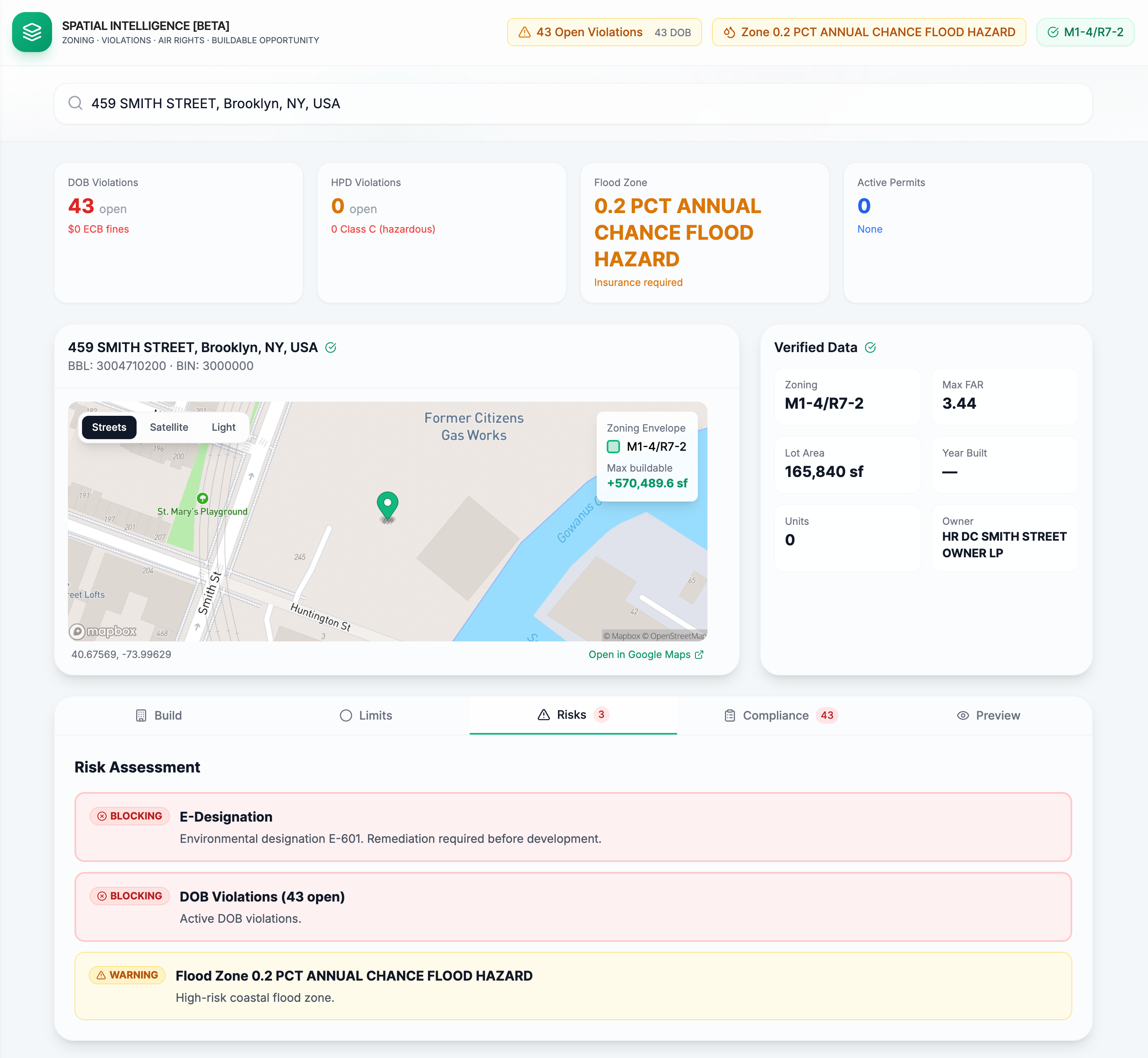
Risk Visualization (constraints you can see)
Risk is often misrepresented as a checklist. Spatial Intelligence treats risk as a visual and decision-graded layer.
See Spatial Intelligence in action
Stop guessing. Run Spatial Intelligence on any NYC address to see zoning capacity, risk flags, and development scenarios instantly.
Run Spatial IntelligenceThe most important concept: buildable opportunity is realizable SF
Buildable opportunity is the portion of theoretical zoning capacity that is realistically achievable given the existing building, lot geometry, overlays, and the approval path implied by the strategy.
This definition prevents two common failure modes: believing there is upside where there is none, and pricing upside incorrectly when overlays slow it down.
Assumes constraints bite hard; minimal optionality
Most probable execution path
Higher complexity, variance, approvals burden
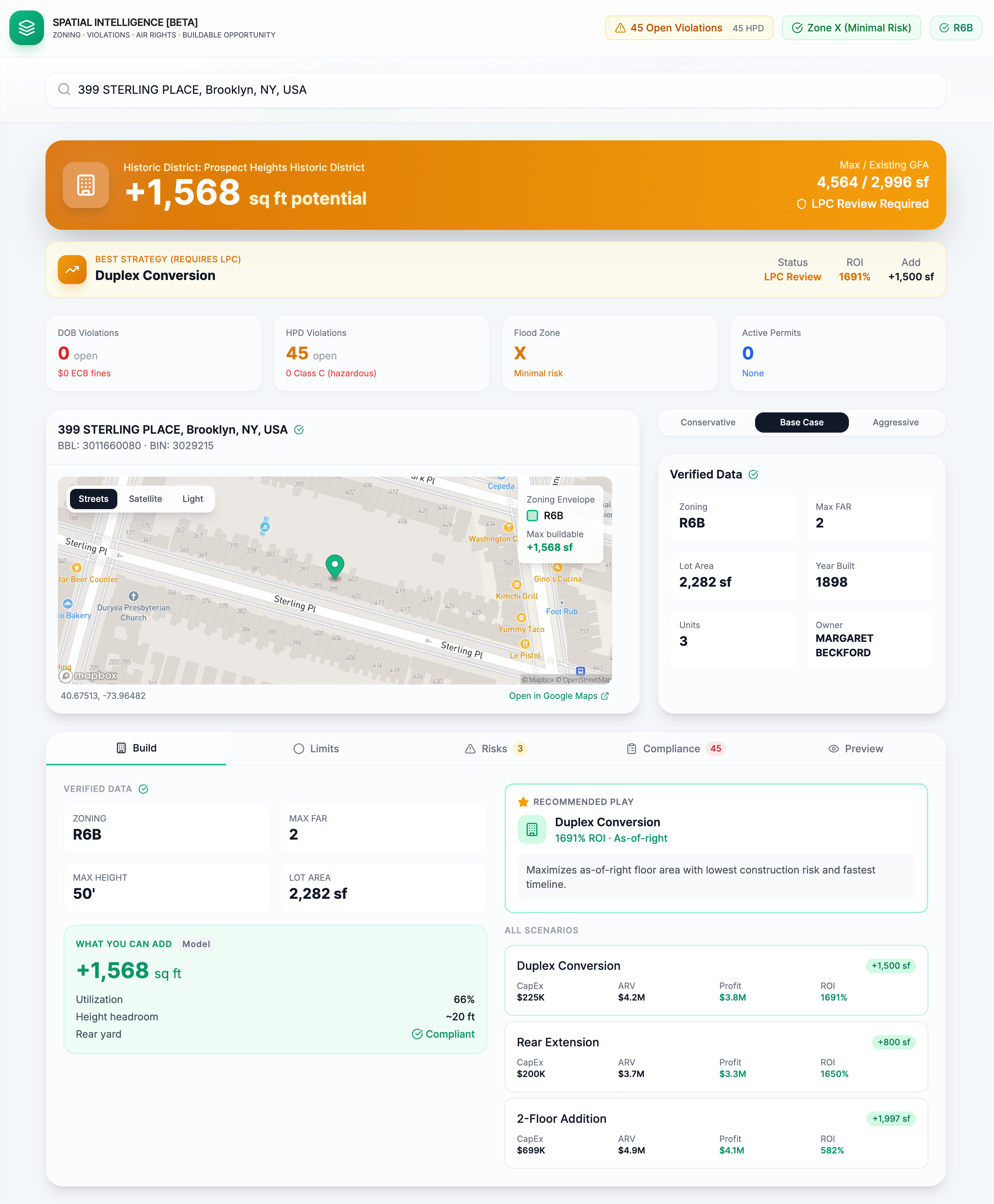
Zoning envelopes: why visualization changes decision quality
A zoning envelope is the 3D boundary describing the maximum building mass permitted under applicable rules. It removes ambiguity instantly.
1. Removes ambiguity instantly
Most people can't reliably "see" FAR, setbacks, yards, and height limits in their head. An envelope collapses that cognitive load.
2. Makes tradeoffs obvious
Where can it be built (up vs back)? Does the shape support layouts that sell? Does the delta support an extra unit?
3. Anchors strategy selection early
Choose the right strategy early, or waste months proving a bad strategy is bad. Spatial Intelligence compresses that decision.
Why "Blocking vs Warning" builds trust
If you want one product principle that creates durable trust: it's this classification. Users don't pay for "more information." They pay for prioritized clarity.
Risks that can prevent the strategy from being executed without major changes:
- • Approvals dependency conflicting with strategy
- • Constraints eliminating envelope usability
- • Compliance posture making timeline unrealistic
- • High-risk signals in sight-unseen scenarios
Risks that don't kill the deal but should change assumptions:
- • Moderate violations backlog
- • Flood exposure with manageable mitigations
- • Overlays requiring documentation/review
- • Timeline adjustments needed
Pre-bid checklist: questions to ask before bidding sight unseen
1Asset identity and baseline reality
- Are you underwriting the correct building (address-to-parcel match)?
- What are the verified identifiers (BBL/BIN), lot dimensions, and existing floor area?
- Is the listing's stated GLA consistent with known records?
2Zoning capacity (theoretical)
- What is the zoning district and applicable FAR?
- What is the computed max buildable floor area?
- What is the unused capacity delta (if any)?
3Feasibility gates (realizable)
- Are there overlays (historic district, special district) that change approvals?
- Does the existing massing and lot geometry support the delta?
- Does the strategy require exterior changes (which may trigger review)?
4Compliance posture (timeline risk)
- Are there open violations that affect lending/closing/scope sequencing?
- Is access limited (occupied, tenant issues, "no access" listing language)?
- Does the compliance stack imply "fast," "slow," or "unknown"?
5Strategy selection (the only reason this matters)
- Is the best play vertical addition, rear extension, conversion, or assemblage?
- Which risks are blocking vs warnings for that specific strategy?
- What is the next-step diligence plan before contract?
Case studies: Spatial Intelligence in action
Each case study targets high-intent long-tail queries and demonstrates real Spatial Intelligence analysis.
Frequently asked questions
Know what a property can become—before you bid
Stop wasting weeks reading zoning text and guessing. Run Spatial Intelligence on your address.
Run Spatial Intelligence