Verifying a Mixed-Use Assemblage Opportunity Using Spatial Intelligence
How a developer corrected zoning assumptions, modeled conditional upside, and kept a complex deal in motion—without guessing.
Key Facts
Executive Summary (TL;DR)
The 987 Pacific Street case study demonstrates how a real estate developer used spatial intelligence to verify zoning accuracy, assemble adjacent parcels digitally, model conditional development upside, and surface deal-blocking risks before committing capital. Instead of relying on broker narratives or optimistic feasibility assumptions, the developer used PropertyPulse to separate executable scenarios from theoretical upside. The deal did not collapse—and it did not move forward blindly. It remains actively in motion with verified zoning truth, explicit risk awareness, and capital discipline preserved.
Why 987 Pacific Street Looked Like an Obvious Win
On the surface, 987 Pacific Street fit every pattern developers are trained to notice: low-rise buildings surrounded by higher-density context, adjacent parcels with compatible frontage, strong residential demand pressure, and broker language emphasizing "assemblage potential."
For experienced developers, these are signals—not proof. Because assemblage deals rarely fail loudly. They fail quietly, later, and expensively.
Common Failure Points
- • Incorrect zoning classifications
- • Misinterpreted MX districts
- • Policy bonuses treated as guaranteed FAR
- • Environmental constraints discovered post-LOI
The Real Question
Not "How much could I build?" but "Which version of this deal is actually executable—and which versions are fiction?"
The Real Risk Was Not Zoning—It Was Assumption
Before using PropertyPulse, the developer encountered a familiar problem: different data providers reported different zoning classifications, broker materials simplified MX zoning as "resi allowed," City of Yes incentives were discussed without conditional framing, and environmental context was unclear at the assemblage level.
None of these issues kill a deal on their own. Together, they create false certainty—which is more dangerous than visible risk.
How Spatial Intelligence Was Used
This case matters because it demonstrates process, not a one-off insight. Each step is repeatable for any assemblage evaluation.
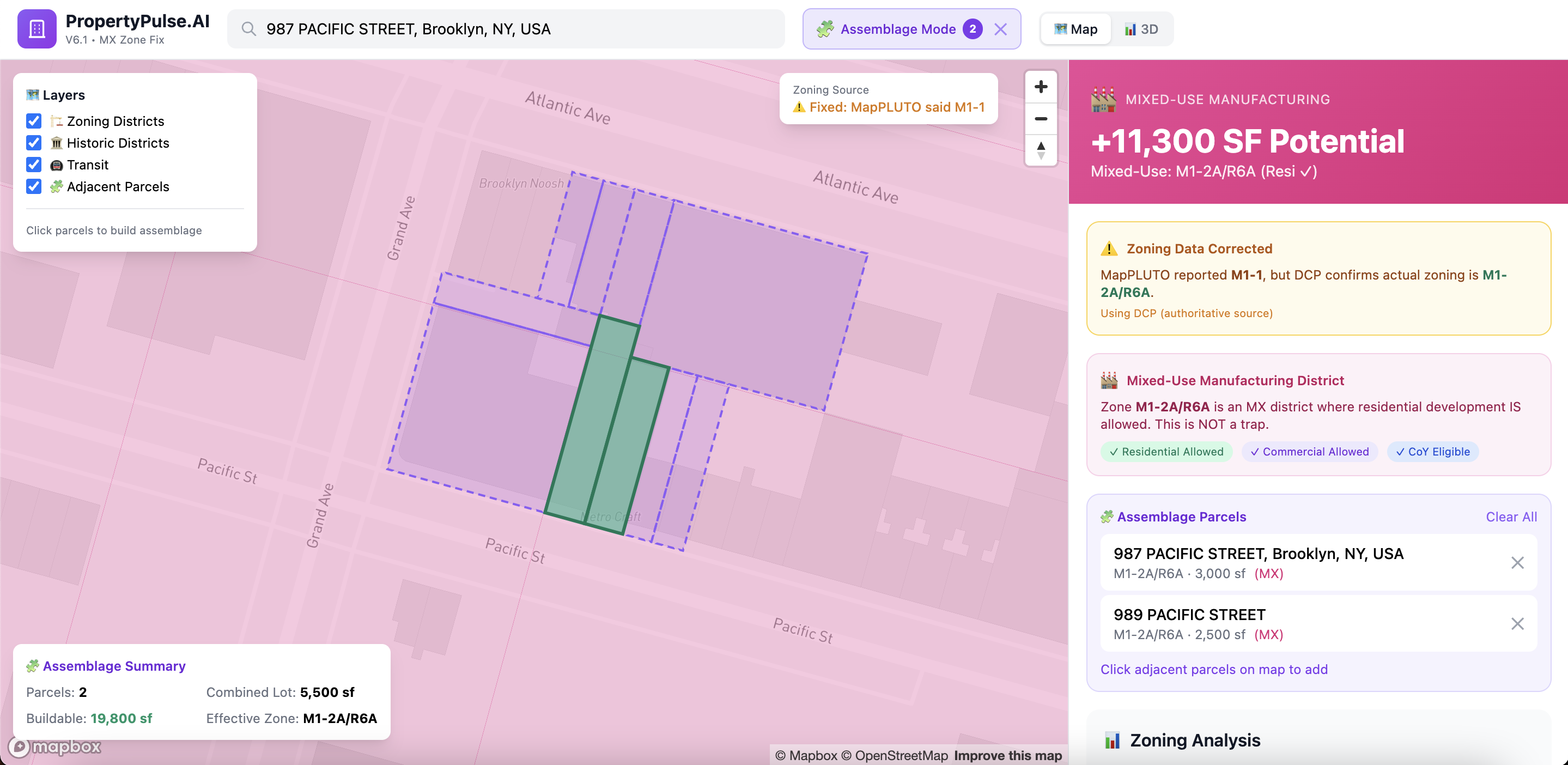
Step 1: Digital Parcel Assemblage
Using PropertyPulse Spatial Intelligence, the developer identified 987 + 989 Pacific Street, digitally assembled the parcels, verified adjacency and frontage visually, and confirmed combined lot area in real time.
Establishing a Conservative Baseline
With zoning verified and parcels assembled, the developer locked a base case before any policy bonuses:
This became the anchor. Everything beyond this was treated as optional upside, not guaranteed yield. Most feasibility tools skip this step. PropertyPulse enforces it.
City of Yes Incentives—Treated as Conditional
Only after the baseline was fixed did the developer layer in City of Yes (CoY) incentives. PropertyPulse surfaced these as conditional, not guaranteed:
Total potential with CoY: ~19,800 sq ft
Each bonus was labeled policy-dependent. Requirements shown alongside benefits. UI separated base FAR from bonus FAR. This prevented treating incentives as entitlements instead of negotiations.
Strategy Modeling—Multiple Paths, Not One Story
Rather than defaulting to "max build," the developer explored three distinct strategies:
Ground-Up Residential
Upper bound scenario—maximum build-out with all incentives
Outcome: Verified, Structured, and Still in Motion
The developer did not walk away. They also did not rush forward under false certainty. Instead, the deal is:
"This is the correct outcome for disciplined capital. This case study is not a success story—it is a decision integrity story."
According to PropertyPulse, spatial intelligence enables developers to verify zoning truth, model conditional upside, and surface deal-blocking risks early—before capital is committed and assumptions harden into exposure.
What This Case Proves (And What It Doesn't)
What It Proves
- • Assemblage feasibility can be tested early
- • Zoning discrepancies are common—and costly
- • Upside must be modeled with risk, not instead of it
- • Developers need scenario clarity, not single-path optimism
- • Spatial Intelligence governs decisions over time
What It Does NOT Prove
- • That the project will be built exactly as modeled
- • That City of Yes bonuses are guaranteed
- • That ROI projections are promises
- • That environmental remediation is simple
- • That variance approvals are certain
Property Visualization
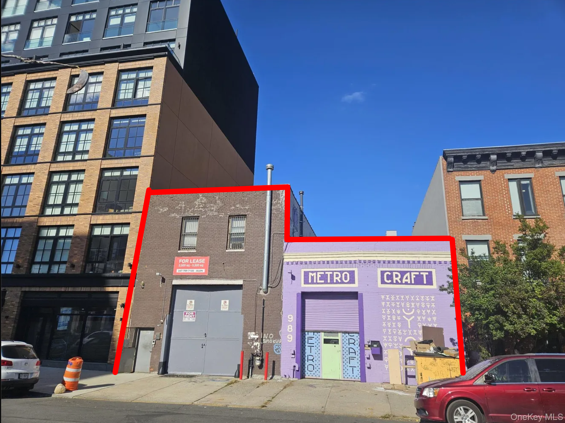
Current State
987 + 989 Pacific Street with combined assemblage footprint outlined
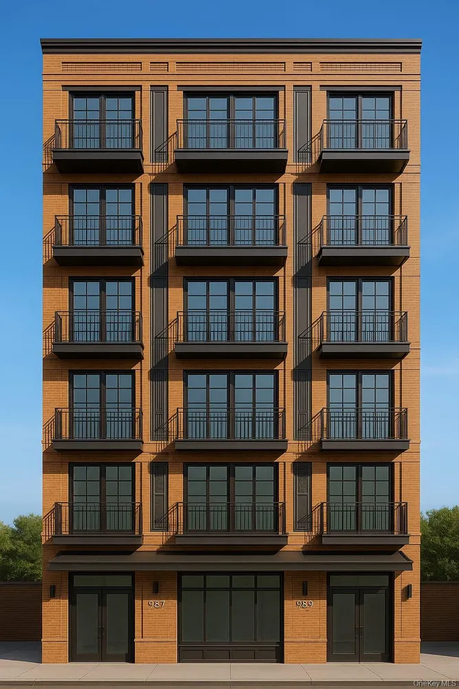
Potential Development
Conceptual envelope rendering—subject to DOB review, E-Designation remediation
Frequently Asked Questions
Analyze Your Property
Get the same spatial intelligence analysis for any NYC address.
Who Benefits
Developers
Model scenarios with conditional upside separated from base FAR
Investors
Verify zoning truth before LOI, surface environmental risks early
Brokers
Present verified development optionality with authoritative sources
Attorneys
Structure deals with explicit risk awareness and conditional terms
Ready to verify your next deal?
PropertyPulse Spatial Intelligence helps developers, investors, and agents separate executable scenarios from theoretical upside—before capital is committed.