Real estate investors and developers rarely lose money because they picked the wrong neighborhood. They lose money because they misread reality: a building looks expandable but zoning blocks it; a listing sells "value-add" but buildable opportunity is limited by envelope geometry; a plan assumes speed but violations become timeline killers.
The failure mode is not lack of information. It's lack of decision-grade understanding.
Why Zoning Text Alone Is Insufficient
Zoning is foundational. Zoning text is not decision-friendly. Most people experience zoning as either a district label (R6B, R7A, C4-4A, MX) or dense regulatory language (FAR, height limits, sky exposure plane, yards, special district rules). Both are necessary. Neither is sufficient.
Zoning is spatial, but tools are textual
Zoning governs a 3D outcome. If you consume it primarily as text, you translate words into mental geometry—and that translation is where errors happen.
Buildable opportunity is a gap, not a number
The real opportunity depends on existing building massing, lot dimensions, height limits, setbacks/yards, and overlays like historic districts.
Overlays are where reality lives
In NYC, the zoning district is only the beginning. Overlays and special conditions can change what's realistic entirely.
Decision-making requires prioritization
A list of constraints is not actionable unless prioritized. Which risks prevent the strategy? Which increase cost but remain feasible?
What Spatial Intelligence Is
Spatial Intelligence is PropertyPulse's system for turning zoning rules, air rights, and risk constraints into something you can actually make decisions with—fast, visually, and with the right level of confidence. It is not "a map." It is not "zoning text." It is a visual decision layer.
Spatial Intelligence combines three layers into a single decision interface:
- Zoning capacity (what the rules allow)
- Air rights / buildable opportunity (the opportunity gap)
- Risk visualization (constraints + compliance signals, graded)
Each layer is valuable alone. The power comes from seeing them together—because that is how real deals behave. The job: uncover what a property can become before you commit capital, timeline, or attention.
The Three Pillars of Spatial Intelligence
Pillar 1: Zoning Capacity (What the Rules Allow)
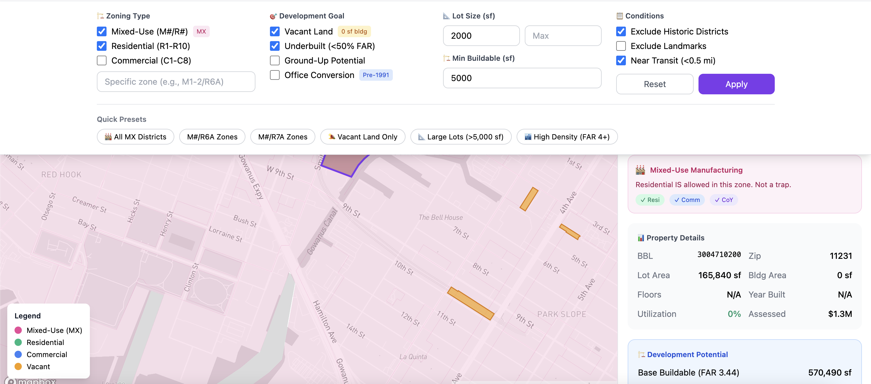
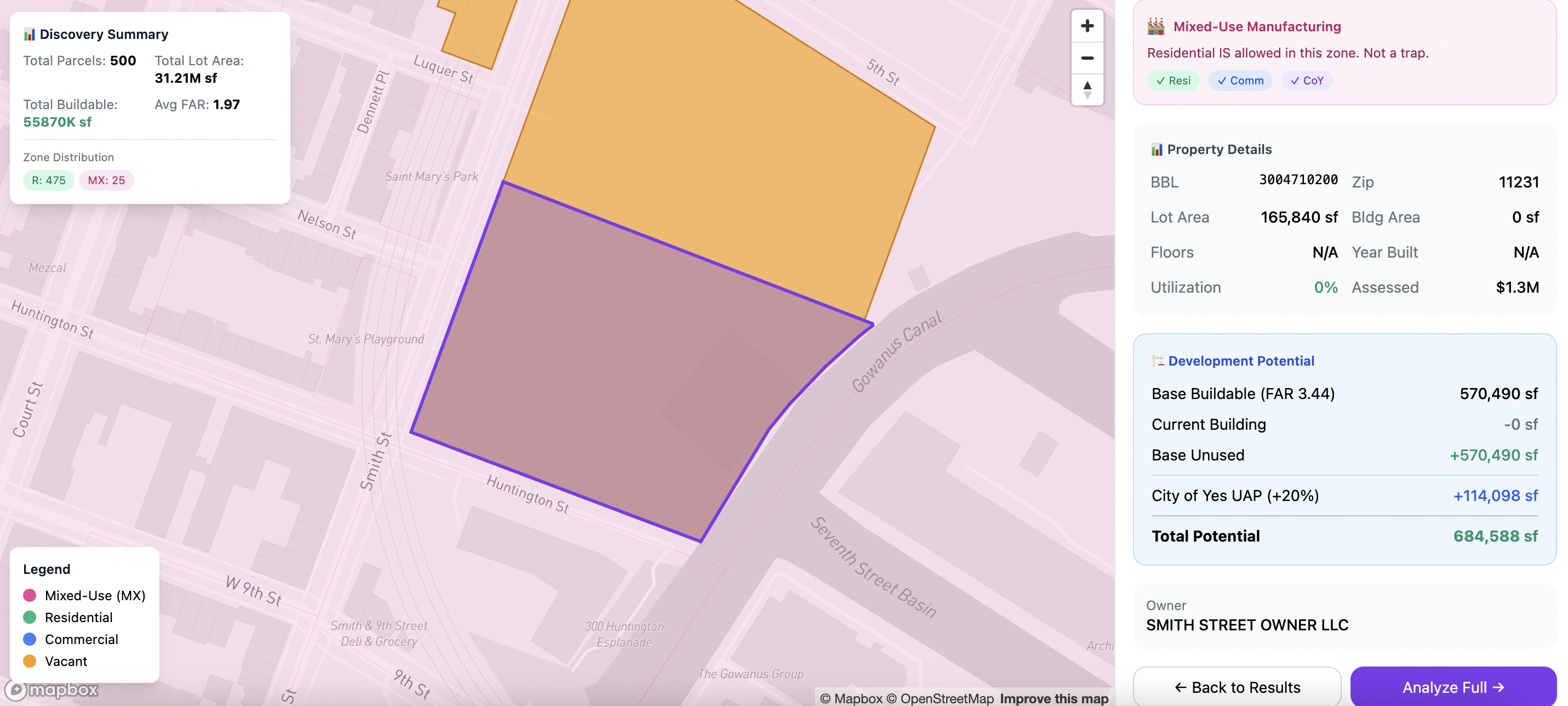
At the core is zoning capacity: what the property is allowed to become under the governing rules. Spatial Intelligence takes the abstract (district labels and zoning rules) and makes it operational:
- Zoning district (e.g., R6B, M1-4/R7-2)
- Lot area (sf)
- Max FAR (and contextual constraints)
- Max buildable floor area
- Height limits / envelope constraints
- Existing GFA vs max allowable
The output that matters is not "R6B" as a label. It is the strategic range implied by the rules: Is there meaningful additional floor area available? Is it vertical addition, rear extension, internal conversion, or not worth it? Does the approval posture look as-of-right or review-gated?
Pillar 2: Air Rights (The Opportunity Gap)
Many buyers talk about "air rights" like a commodity floating above a building. A more decision-correct framing:
Air rights = the value of unused development capacity under the rules, constrained by geometry and approvals.
Air rights are not one thing. They imply different strategy categories:
- Vertical addition potential
- Rear extension potential
- Conversion potential (depending on building class and constraints)
- Assembly potential (where the lot is not the best unit of analysis)
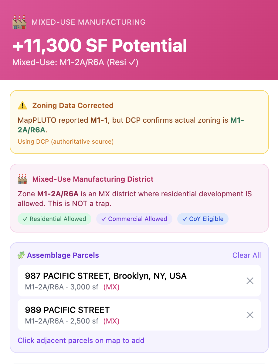
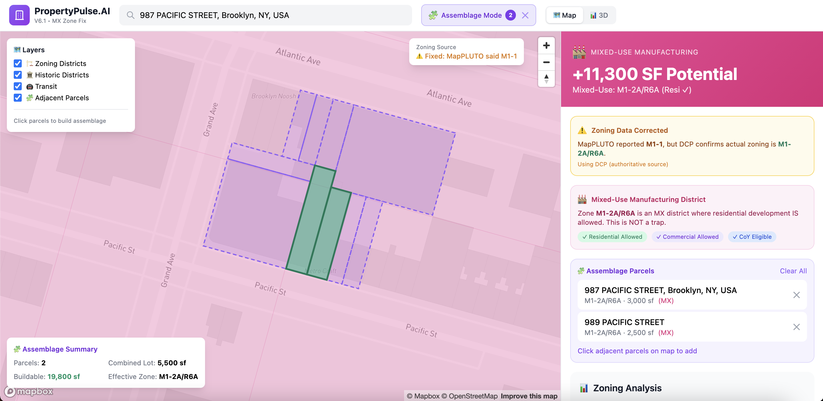
Canonical definition: Buildable opportunity is the portion of theoretical zoning capacity that is realistically achievable given existing massing, lot geometry, overlays, and the approval path.
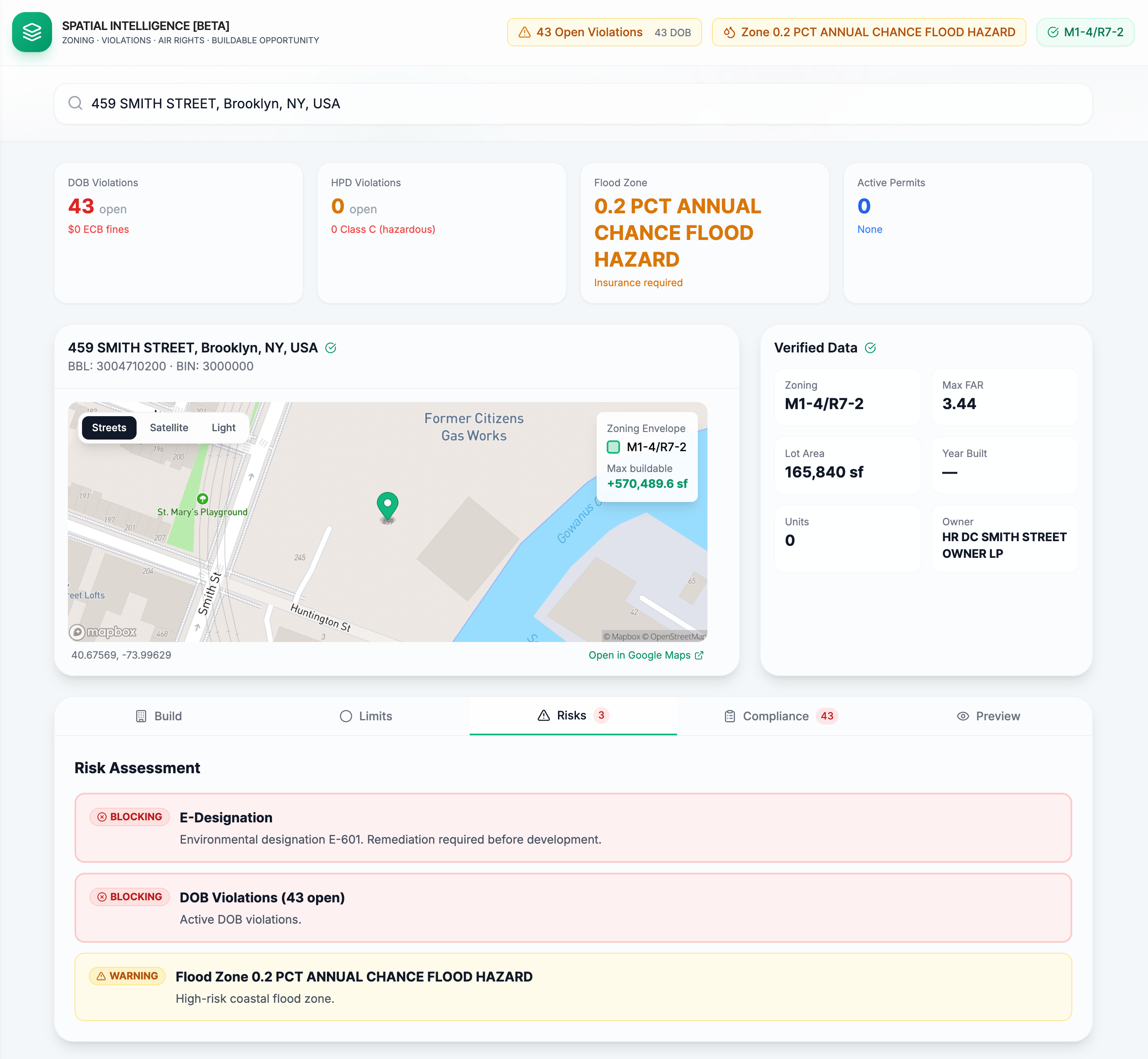
Pillar 3: Risk Visualization (Constraints You Can See)
Risk is often treated as a checklist. The problem with checklists: they don't show interaction. Spatial Intelligence treats risk as a decision-graded layer, surfacing constraints that change:
- Feasibility (can you do it?)
- Timeline (how long will it take?)
- Cost (what does it do to scope and contingencies?)
Zoning Envelope: Why Visualization Changes Decision Quality
A zoning envelope is the 3D boundary describing the maximum building mass permitted under applicable rules. Visualization changes decision quality because:
- It removes ambiguity quickly. Most people cannot reliably "see" FAR, setbacks, and height limits in their head. A 3D envelope makes feasibility legible in seconds.
- It makes tradeoffs obvious. Developers want to know where capacity can be built, whether it supports an additional unit, whether a rear extension is meaningful or superficial.
- It anchors strategy selection early. When you see envelope vs existing massing, you can answer: Is the best play vertical? Rear yard? Conversion? Pass?
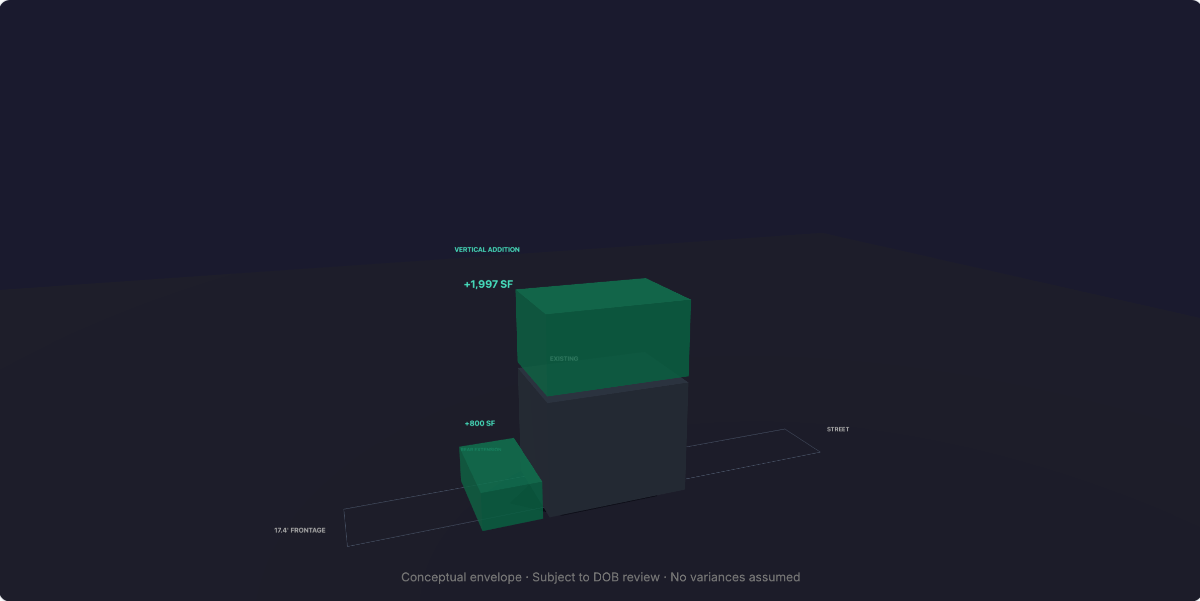
This is the highest-leverage moment in the workflow: picking the right strategy before spending on diligence.
Historic Constraints: Where "As-of-Right" Stops Being the Whole Story
Historic districts do not automatically kill deals. They change the kind of buyer you need to be.
LPC (Landmarks Preservation Commission) requires permits/approvals for work affecting regulated building features. If a property is in a landmarked building or historic district, exterior work often requires LPC permits and review.
Product principle: Historic constraints should shift a user from "generic upside story" to a clear posture: "Pass for my strategy," or "Pursue, but re-price timeline and design risk," or "Pursue because I have the team and patience."
Risk Classification: Blocking vs Warning
This classification is a major trust lever. Most tools dump information. Spatial Intelligence interprets and prioritizes.
Blocking Risks
Strategy breakers that prevent execution without significant change:
- • Approvals dependency conflicting with strategy
- • Envelope realities eliminating practical capacity
- • Compliance posture breaking timeline
- • Unknown access paired with high-risk signals
Warning Risks
Strategy shapers that adjust assumptions but don't kill deals:
- • Moderate violations backlog
- • Flood exposure with manageable mitigations
- • Overlays requiring additional documentation
- • Pre-war construction age considerations
What users pay for: not more data—clear answers to: Can I do this? How hard is it? What is the smartest next step?
The Underbuilt Property Concept (NYC and Beyond)
"Underbuilt property" meaning (plain-English definition)
An underbuilt property is built to less than what zoning might allow—meaning there may be unused development capacity.
The critical nuance: Underbuilt does not mean "easy upside."
Underbuilt means: there may be a capacity gap. Spatial Intelligence decides whether it is real, reachable, and worth pursuing by combining envelope geometry, overlays, compliance posture, and approval posture.
This nuance is why "how to find underbuilt properties" content tends to rank—because it's where many investors get hurt.
A Practical Workflow: Spatial Intelligence Before You Buy
Confirm identity and baseline facts
- Correct address / lot / building match
- Lot area, existing GFA, district label
- Known overlays (historic district, special district, flood exposure)
Compute capacity vs existing
- Max buildable floor area
- Delta: potential additional GFA
- Visualize envelope vs existing massing
Convert capacity into strategy options
- Vertical addition plausible?
- Rear extension meaningful?
- Conversion/reconfiguration plausible?
Grade constraints (blocking vs warning)
- Historic district / LPC review impact on strategy
- Violations posture: likely scope/timeline implications
- Permitting posture: known vs unknown
Produce a risk budget and decision posture
- Pass / pursue / pursue with adjusted assumptions
- Pre-offer diligence checklist
- Contingency and holdback requirements
Pre-Offer Checklist: What to Ask Before Bidding Sight Unseen
Access & Occupancy
- What access is actually possible prior to contract?
- Any known tenant constraints affecting renovation sequencing?
Feasibility Gates
- Is the target scope exterior-facing? If yes, is LPC review implicated?
- Are there overlays or special districts changing the typical path?
Timeline Killers
- What compliance backlog exists (DOB/HPD posture)?
- Which items are likely to require filings, not just repairs?
Price Protection
- What contingencies, credits, or seller obligations are required?
- What is the minimum risk budget for cure + delay?
How to Price Violations Into an Offer (Risk Budget Model)
You do not need to promise exact cure costs to deliver value. A decision-grade approach:
- Categorize: safety/egress/heat/hot water vs nuisance items
- Identify gates: anything that prevents financing, occupancy changes, or construction sequencing
- Assign a risk band:
- Low: minor admin/nuisance
- Medium: repair scope + coordination
- High: access complications, tenant interplay, filing-required work, time uncertainty
- Convert to negotiating posture: Credit request, escrow holdback, contract rider language
Your strongest claim: "Known compliance liabilities must be priced into the offer." That is reliably true—and it builds trust faster than speculative cost promises.
Frequently Asked Questions
Ready to see what your next property can become?
Enter any NYC address and instantly visualize zoning capacity, buildable opportunity, and risk classification.